A coordinate is not a closure
Roadworks are among the most useful data a road authority can publish. Under the EU's rules for real-time traffic information, they do so on National Access Points, NAPs for short: in Germany on Mobilithek, in the Netherlands on the NTM, in Norway on transportportal.no, and so on. The format is almost always DATEX II, the European standard for traffic data, in version 2 or 3.
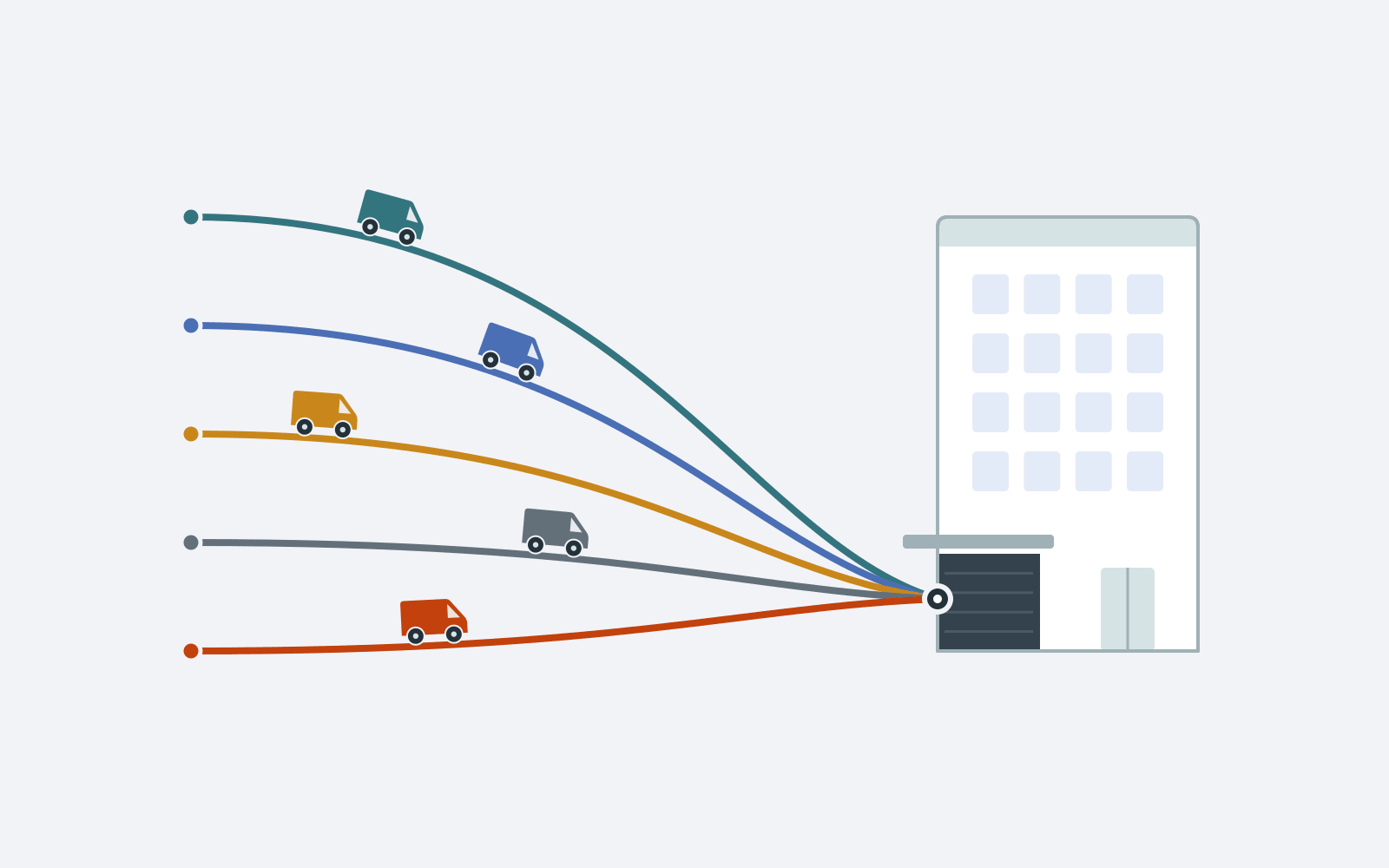
For a navigation provider, every one of these records raises the same questions. Which road does it mean? In which direction? Which lanes are affected, and which road users: cars, cyclists, pedestrians? And the decisive one: is the road really impassable, or only restricted? A route that avoids a road that is in fact open costs time. A route through a road that is in fact closed costs more.
A roadworks record is only as useful as the road, the direction and the lanes it can be tied to.
The feeds themselves rarely answer these questions at a glance. A typical file is a few megabytes to a few hundred megabytes of XML, with thousands of records, each with its own validity, location reference, lane codes and links to other records. Whether a feed is good enough for routing is hard to see from the outside, both for those who use it and for those who publish it.
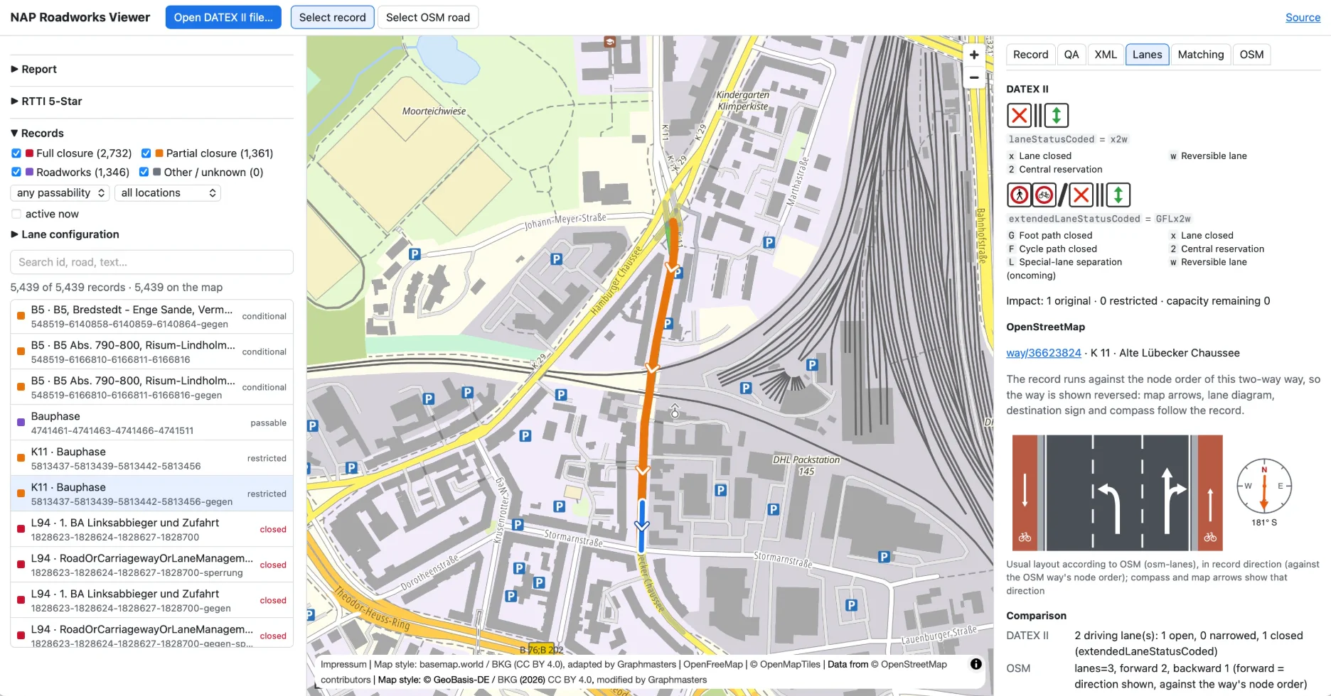
That is why we built the NAP Roadworks Viewer: a tool that opens such a file, checks it and shows each record on the map, lane by lane, next to the road network of OpenStreetMap.
From feed to road in four steps
The viewer works through a file in four steps. Each one can be followed in the interface.
- Check: Is the XML well-formed, which DATEX II version and profile does it use, does it pass schema validation?
- Locate: Where is each record on the map, and which OpenStreetMap road does it belong to?
- Interpret: What do the lane codes say, compared with the usual lane layout of that road?
- Routing hint: Is the record passable, restricted, closed or contradictory, and should a router block the road, leave it open or ask for a manual review?
Check
The file is read as a stream, with the XML parser saxes, so even large feeds open quickly. A feed with 61,000 records and 209 MB of XML (16 MB compressed) works in the browser. The viewer reports the first XML error with line and column, detects the DATEX II version, the publication type, its creator and time, and whether the data is wrapped in a SOAP envelope. DTDs and external entities are never resolved.
For real schema validation, you select the XSD files of your profile. The viewer validates against them with libxml2, right in the browser. Until you do, the interface says "not performed" instead of pretending. On top of that come profile checks for common national profiles, such as the German roadworks profile, and for generic DATEX II v2 and v3. They are heuristics and labelled as such. Extensions are counted and listed, the official DATEX II extension mechanisms apart from other namespaces.
Locate
For each record, the viewer uses the best location reference the record carries. Where that reference describes the line itself, the record is drawn as that line. Where it gives only a point, or only the reference points of a line, the viewer draws an approximation and marks it as such. Records the viewer cannot place are listed with the reason.
Then comes the step that turns a line into a road: matching. The viewer compares the record with the OpenStreetMap roads around it, by distance, direction, road number and road class, and scores the candidates. Long records can be explained by several consecutive roads. If the best candidates are too close to call, it says "ambiguous". If none fits, "no match". The score ranks candidates; it is not a probability.
Interpret
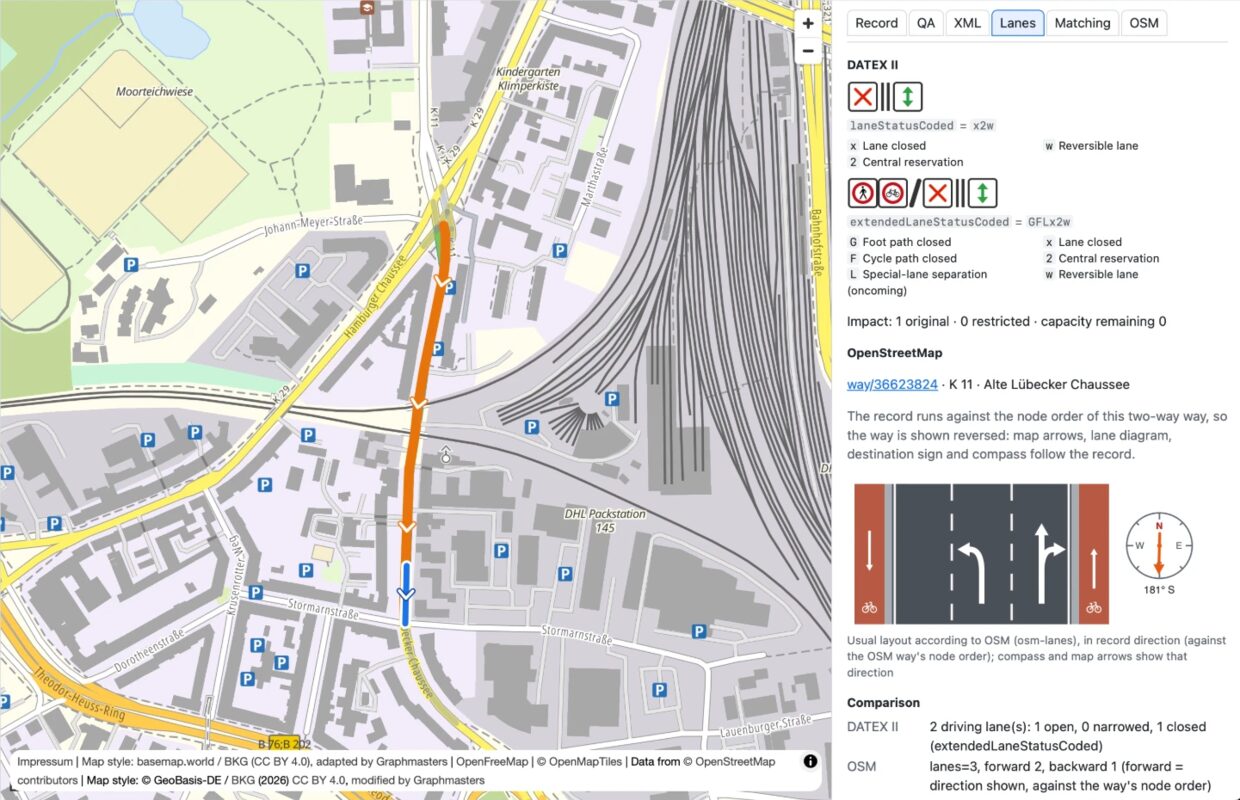
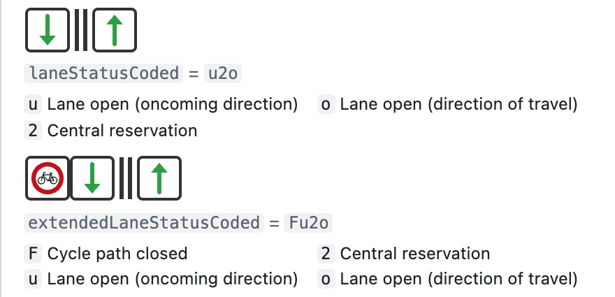
DATEX II can describe the lanes of a roadworks site very precisely. The German roadworks profile, for example, encodes them as short strings: which lanes are open, closed or reversible, whether the hard shoulder is in use, and whether foot and cycle paths are closed. The viewer turns these codes into lane diagrams and places them next to the lane layout of the matched road in OpenStreetMap. Both diagrams come from our own open-source libraries: lane-status-viewer draws the DATEX II codes, osm-lanes the OpenStreetMap lane tags. Arrows on the map and a compass next to the OpenStreetMap lane layout show in which direction that road is drawn. A difference between the two diagrams is a hint, not an error: OpenStreetMap describes the usual layout, DATEX II the temporary one.
The lane codes also feed a filter. With one click, the record list shows only records with a closed lane, a reversible lane, an open or closed hard shoulder, or a closed cycle path.
Routing hint
From everything above, the viewer derives one classification per record: passable, restricted, closed, conditional, conflicting or unknown. With it comes a routing action: block, do not block, or manual review. The reasons are listed, so the classification can be checked rather than believed.
Restricted, closed or contradictory?
Not every roadworks site closes a road. A frequent case: the cycle path is being rebuilt while both driving lanes stay open. If the feed encodes the lane status, the viewer recognises this and classifies the record as passable for cars. If the feed only says "roadworks", a router cannot tell such a site from a lane closure. Publishers who encode lane status give routers exactly the information they need.
The viewer also looks for records that contradict themselves or each other. Two typical patterns:
- A record reports a full closure, but the record it names as its cause only describes a no-stopping or no-parking zone, with all lanes open.
- A record reports a closure, but its own lane status keeps lanes open in both directions.
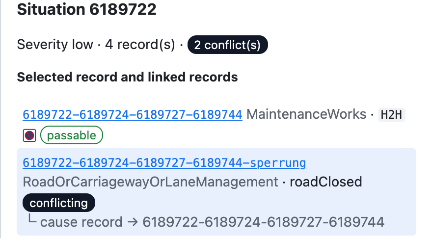
Both cannot be true at the same time. The viewer does not decide which part is right. It recommends a manual review and not blocking the road on this record alone, because only the publisher can say what is really happening on site. If a closure and its cause are never valid at the same time, the viewer does not mark the closure as conflicting.
How good is the feed? RTTI 5-Star ceilings
In October 2025, TISA published the RTTI 5-Star Rating Specification. It rates roadworks and road-closure data per criterion from one to five stars: data format, location referencing, a polyline with an unambiguous direction, stable message IDs, correctness, completeness, outdated messages and more.
A single file cannot settle all of that. Update cycle, timeliness or availability only show over many downloads. The viewer therefore shows something more modest and more honest: per criterion, the highest level this file allows. A ceiling, not a rating. A feed cannot score higher on that criterion, but may score lower once the remaining criteria are measured. The viewer shows no overall star value.
The ceilings are useful precisely because they point to concrete fixes. Typical findings:
- A record has only a point: add a line, and the ceiling for the polyline rises from zero to five stars.
- The direction is not tied to the line: state it on the line, from two stars to five.
- Message IDs are reused: stable unique IDs, from two stars to five.
- The end time is missing: add it, and completeness improves.
- DATEX II v2: moving to v3 and a reference profile raises the format ceiling from three stars to five.
- Coordinates only: adding OpenLR, a map-independent location reference, raises the location ceiling from three stars to five.
Each finding links to the affected records. The QA tab of a record shows which criteria it holds down and why.
As a data provider, you can request an External RTTI 5★ Gap Analysis from TISA. The viewer does not replace it, because it has a different purpose: a quick look at the technical properties and possible problems of your XML feed. It runs in your browser on your own computer, and since it is open source, you can review every line of its code.
What it does not do should be as clear as what it does:
- Update cycle
- no statement on update cycle, timeliness or availability from a single file
- Star rating
- ceilings from selected criteria, not an official TISA rating
- Matching
- scores rank candidates; they are not probabilities
- Contradictions
- a flagged contradiction calls for review; it proves no error
- Location methods
- not every location method is decoded; approximate locations are marked as such
Bring your own data
The viewer contains no feed data. You download the DATEX II file from the NAP yourself, then open it or drop it into the window, as plain XML or compressed with gzip. We have tried the checks on seven feeds from six countries: Germany, the Netherlands, Norway, Denmark, Slovenia and Croatia.
When you publish screenshots or results from a feed, please credit its publisher as their licence requires.
Open source, and open for more
The NAP Roadworks Viewer is open source. Its source code is on GitHub, under the Apache License 2.0: the code may be used and changed, commercially too, and passed on, as long as the licence and copyright notices stay with it and changes are marked. The analysis also runs without the interface, in the browser or in Node.js, so the same checks can run in a pipeline. The code was generated with Claude (Anthropic) under human direction and review.
Which checks do you need for your feed? We welcome issues and pull requests on GitHub.
What stays in your browser, and what does not
The viewer is a self-contained web app. It has no backend, and it does not use any Graphmasters servers: the app itself is served as static files from GitHub Pages.
Your DATEX II file stays on your device. It is read and analysed locally in your browser, and neither uploaded nor stored. That matters for feeds that require an account or are not yet public.
What the viewer does load from the internet is the map and the road network. Because the map follows your records and the matching looks up the roads around them, these requests show roughly where your records are. No other data from your file is sent. The privacy page of the documentation lists every service the viewer contacts and what each request contains.
Our thanks go to OpenFreeMap, the German Federal Agency for Cartography and Geodesy (BKG) for basemap.de, the OpenStreetMap Foundation, FOSSGIS e.V. and private.coffee, whose services make tools like this possible for everyone, and to the OpenStreetMap contributors whose data the map and the matching rely on.
Try it with your feed
- Download a DATEX II roadworks file from your National Access Point.
- Open graphmasters.github.io/nap-roadworks-viewer.
- Drop the file into the window.
Everything else, from reading the results to running the checks in your own pipeline, is in the documentation.
The question the viewer helps to answer is the same for those who publish roadworks data and those who route on it: is this road really closed?