If everyone chooses their individually best route, that does not yet mean the best result for everyone. This question has occupied research for decades.
Two levels matter for assessing NUNAV: the scientific foundations of coordinated traffic distribution, and the concrete study of the system in road traffic.
Why individual optimization has limits
In 1968, Dietrich Braess showed in “Über ein Paradoxon aus der Verkehrsplanung” (“On a paradox of traffic planning”) that, under certain conditions, an additional road link can lengthen the travel times of all road users. The reason lies in route decisions that influence one another.
Tim Roughgarden and Éva Tardos examined this relationship in “How Bad Is Selfish Routing?” (2002). They describe mathematically how far an equilibrium of individually optimized trips can be from the best possible overall result.
Roughgarden’s book “Selfish Routing and the Price of Anarchy” (2005) takes this approach further. The “price of anarchy” describes the ratio between the worst such equilibrium and the system optimum. The results depend on the assumptions of the respective model. They are not a blanket savings rate for a navigation app.
Serdar Çolak, Antonio Lima and Marta C. González connect this to real cities in “Understanding congested travel in urban areas” (2016). Using data-driven models for five metropolitan areas, the paper examines what changed route choices can and cannot achieve.
NUNAV in a traffic experiment with the ADAC
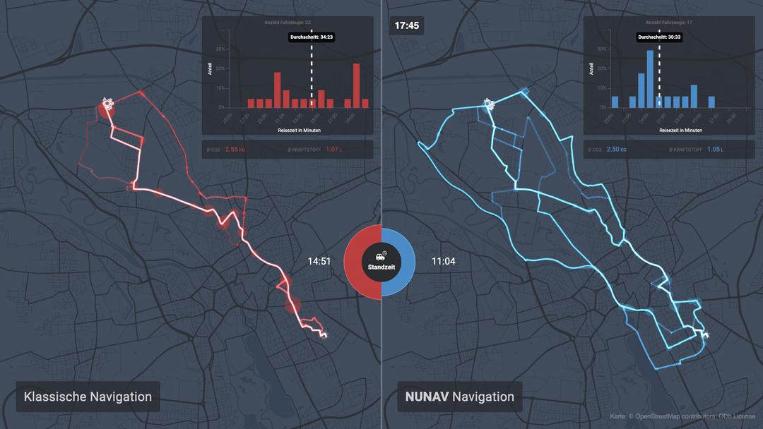
Together with ADAC Niedersachsen/Sachsen-Anhalt, NUNAV was compared with Google Maps in Hanover’s road traffic. The video of the traffic experiment on the Graphmasters YouTube channel is a good place to start.
In addition, the ADAC report (in German) and the driving data and linked scientific analyses in the Traffic Lab repository are available.
This was a jointly conducted field trial. That should be said when putting it into context – just like the reference it used: Google Maps.
Also, NUNAV’s share within the test group cannot be equated with NUNAV’s share of overall road traffic.
What was measured – and what was derived from it?
Travel time, vehicle kilometers and emissions answer different questions.
Recorded trip traces allow travel times, distances driven and standstill phases to be examined. If emissions are calculated from them, additional assumptions come in, for example about vehicles, drivetrains and consumption behavior. A calculated emissions figure remains a model calculation.
In the same way, the result of individual trips has to be distinguished from the result for the entire network. A faster trip first of all proves an advantage for that trip. A statement about the network effect also has to account for the effects on other vehicles.
The research cited explains why coordinated route choice can make benefits possible. The traffic experiment examines concrete trips with NUNAV. Together, they provide a sound basis – as long as measurement, model and transfer to other situations remain recognizably separate.